-->

Featured Post

Shi Shi Beach - Olympic Peninsula, WA

After dropping our parents to Sea-Tac airport, we decided to spent couple days in Olympic National Park.  Our plan was to spend a night...

Arrowhead Lake - Obsidian Limited Entry Area

Start Point: Obsidian Trailhead or OR-242
Hiking Stats: 13 miles, 3000 feet elevation gain


Abiqua Falls

On a cloudy day of Autumn, a friend and I decided to head down to Abiqua falls on the boundary or Silver Falls State park. This place has been on my list for last couple of years, but I didn't have 4x4 drive to make it to the trailhead. Getting to the trail, definitely needed one. Once we got there, going down to the creek has steep, but simple enough for us. There were parts with a rope assist, but I felt that you don't necessarily have to hold on the ropes -- may be it is needed in the spring time when trail is mossy and slippery.

I had seen hundered of pictures before visiting the area, so I knew what to expect at the end of the trail But even then, the first time I got a glimpse of the waterfalls and surrounding cliffs, I was amazed by the sheer scale of it. Astonished!


Mount Hood Gnarl Ridge

Mount Hood from top of Gnarl ridge
Total mileage - 12 miles
Elevation Gain - 2600ft
Starting TH - Hood River Meadows Trailhead

Starting at Hood River Meadows TH, we crossed the Clark Creek on the footbridge. Shortly after crossing that, we crossed the Newton Creek on Gnarl Ridge trail. Here I had to make a call by looking the water level whether to make a loop through Timberline trail or come back the the way we went it. We were able to rock hop the creek and seemed like the upper crossing wouldn't be too bad. We quickly climbed out of the canyon and headed towards Elk Meadows. After having a quick snack break by the shelter, it was time for the final push towards Lamberson Butte atop Gnarl Ridge. It was a clear day with no wind, so we ended up spending good 30-40 minutes soaking in the views.

After having relaxing lunch, we headed out the way we came and then took Timberline trail down to Newton Creek trail. Crossing the creek here was a bit more challenging than the lower crossing, but we were still able to do it dry feet. In the past, there was a rope here to climb out of the canyon, but that was noticeably gone. I saw few parts of it lying around, but the path up was easily doable without it. Just follow the cairns!


Middle Sister Climb

Total mileage: 18 miles (5 miles from Camp lake)
Elevation gain: 6K feet
Starting trailhead: Pole Creek trailhead
Route: SE Ridge via Camp Lake

This was somewhat impromptu decision. One of my friend ended up posting this on Facebook that it would be cool to summit the Middle Sister. We ended up chatting a bit on the topic and decide, let's go do it.

After researching about the climbing routes, two most obviously taken routes were on the table. North route, which goes along the Hayden Glacier to the saddle between North and Middle sister and Southeast (SE) ridge route - which starts from Camp Lake and follows the SE ridge up to the summit. Considering I don't have any glacier skills, we decided that we shall do the SE ridge route.

We stated from Pole Creek TH. Camp lake is about 7.5 miles from the trailhead. Trail doesn't get steep at any point and we had a leisurely hike in. We got to the camp in the afternoon, after setting up the camp and finishing the camp chores, it was time for dinner. We talked to few climbers that went up on the day and they said, the route was easy to follow, but there was lot of snow and postholing on the way.

Everyone got up at teh crack of dawn and started our hike upto the summit. After gaining the plataue above the lake, we followed a bootpath south. We soon realized that we have gone far too south and SE ridge was behind us. We decided to boulder straight upto gain the ridge. between Saturday and Sunday, considerable amount of snow had melted, so we weren't postholing too much, but shaded patches of snow were far too icy to walk on.
After we gained the SE ridge (Photo Credit: Sam Liao)
Summit Celebration (Photo Credit: Sam Liao)
North View from the summit


Full Screen.

Broken Top Circumnavigation

Start Point: Three Creek Lake TH
Hiking Stats: 25 miles, 4500 feet elevation gain
We started from Three creek Lake on Saturday for a 3-day Labor Day weekend circumnavigation of the Broken Top Mountain. There was still some lingering snow on the ground from the week before. For the first night, we camped on the shores of Golden Lake. Night time temperature dropped down to high 20s. For the second night, we made our way around the mountain, passing Green Lakes to the no-name lake in the crater just below the summit. There weren't many flat spots available here, but we were able to squeeze in 4 tents very close together. It was really windy in the evening, so in order to block the wind at night, we made a 2 feet wall around our tents. Morning was really calm and warm, watching the sun rise and alpenglow over Broken Top was really spectacular. After quick breakfast, we made our way out via Tam McArthur rim trail back to Three Creek Lake. I think the whole way out and the walk on the rim was really amazing with the views of Three Sisters.


South Sister Climb

This is a repeat of the adventure I did a year ago. I was leading different friends up the mountain and hoping for a better sunrise shot.

We started from Devil's lake around noon and it took us just more than an hour to get to Moraine Lake. This time we we went down to the lake to find a designated campsite only to find out that all the designated spots were taken. Finally we did find a spot next to the post.
On the way to Moraine Lake
It was such a hot day, so as soon as everybody was done setting up the camp, we went to the lakeshore and hung out there and had fun in water.
Dinner by the beach
Starting out
We started out at midnight from camp. the weather was perfect - not too cold or windy. We were making good progress, so every now and then we would stop for a minute and turn off our headlamps and stare at the stars in complete silence. Going uphill, we did loose the trail a couple of times, but with the help of gps, we were able to get back on track.

We got to the summit with plenty of time to spare before the sunrise. There were about 4 tents at the summit, but other than that we were the first group. We hunkered down in one of the smaller   windbreak waiting for the sun to come up.
Group shot on the summit looking north towards Middle and North Sister
We probably spent more than an hour on the summit exploring around. One the way back down, we ran into 100s of other hiker going up. It was 9am and it was already getting very hot. Getting the climb out of the way in the cooler weather was probably the best thing to do.
Express way down

Onion Valley (Kearsarge Pass trail) to Whitney Portal

Total Hiking Distance: 48 miles
Elevation Gain (Cumulative): 12096ft
Days spent: 5 days

Planning phase - When I got the permits, I was super stoked that I will be standing on top of Mt Whitney - the tallest peak in contiguous US - this summer. Backpacking wasn't new to me, so planning for food or gear was not much of a big deal. I was mostly researching about cool camp spots with great sunset/ sunrise views. Two months before the hike, I booked my car shuttle between Onion Valley TH and Whitney Portal. Everything was setup for an epic adventure. And then..
All my hiking buddies have already bailed out on me sometimes during the month of June. Here I was..trying to convince myself to go solo and at the same time convincing the family that I can make it. The idea of solo hiking was terrifying to me since I hadn't done anything longer than a solo overnight - let alone 6 days. With me going solo, apart from hiking challenge, there was transportation challenges. I'd have to drive more than 800 miles overnight to get to Lone Pine and start hiking immediately. So, as the days came closer, my excitement started turning into worry and nervousness.
Gear Stack
Day 1:
Start: Onion Valley trailhead
End: Kearsarge Lakes
Hiking Stats: 5.75 miles, 2700 feet elevation gain

My first day started with an adventure. After an overnight drive from Portland to Lone Pine, I got there at about 4AM. After parking my car by the roadside, I took a nap for couple of hours, took a shower at a hostel. I then called my shutter service guy and no answer. I called 10 mins later and some lady answered and she didn't know where he is and told me that she will give my message to him. I wasn't too worried up until now. I picked up my permit grabbed breakfast. That took me almost an hour. So, I call the guy again, same lady answered and said he is in the emergency room. I was like "what the F$*K! what am I going to do now?" After a bit of conversation, the lady on the phone gave me a phone number and said he should help you. I called the other guy, no answer. I call him again still no answer. I started to panic at this time. I thought let me drive to Independence and then I will see if I can hitch a ride to Onion Valley TH. As I was driving, I got a call back and he said I can shuttle you, but earliest he can pick me up will be noon. I had no option but to say yes. This meant that I won't be on the trail until 2 PM. After all this, I finally get to the trailhead just before 2PM. I said my final goodbye and headed uphill. It was a nice sunny day with may be couple of fluffy clouds around.


Afternoon thunderstorms were not even on my mind until now. It was a 6 miles day and I had plenty of day light left, so I was taking my time.By the first couple of miles, I realized that this is not going to be an easy trip. I was already tired and every step that I take was a struggle. An hour or so after I started hiking, I see those cople of fluffy clouds are starting to form into a big thunderhead. Thousand feet below the pass I was and clouds looked very ominous and I started hearing thunder or may be that was just my imagination - I don't know. Finally I get to the top of the pass and dropped my pack for few pictures. I must have spent about 30 mins at the top, snapped few photos and started downhill. By this time I was so tired and out of it, I just wanted to lay down and sleep. I quickly found a campsite by Kearsarge Lakes, shot few sunset pictures and cooked my dinner. I hadn't eaten anything other than couple of pancakes since morning, but I still couldn't finish my dinner (May be altitude effect!)


After settling down in my tent, I looked at my map to plan for the day 2. For some reason when I planned the trip, I though day 2 was "easy pizzy", but after 10 mins of staring at the map, I realized it was not the case.

Day 2:
Start: Kearsarge Lakes
End: Below Forester Pass (11,300 feet)
Hiking Stat: 8.5 miles, 2200 feet elevation gain


I think about this even now when I writing this post. I remember it clearly that on the first night, I was so tired and exhausted and number of things hasn't gone very well. I told myself if I don't start feeling better today then it is time to turn back. I gathered all the mental strength that I could find and started walking along the trail. Very soon I met with JMT and my very first through hiker. Just 5 mins chat with him lifted me up greatly. I made my down to Vedette Meadows and kept following Bubbs Creek Valley. The view was just amazing. Kept stopping for pictures every so often. In fact it was just an excuse for stoping and catching my breath.

Once I was all the way down in the valley, it was time to go around the Center Peak and plan was to camp a mile before the forester pass. Even if the trail climbs very moderately - 2000 feet in 4.5 miles, I was dead tired. I looked at the datebook and found that below 12000 feet lake, there is a campsite with spectacular views and water. When I got there, the view didn't disappoint. I made that spot my home for the night.
Pano from the campsite
Day3:
Start: 11,300 feet (3 miles before Forester Pass)
End: Bighorn Plateau
Hiking Stats: 10.5 miles, 2700 feet elevation gain

I knew I had a long day, so I packed up before the sunrise and snapped a few shots and I was on way upwards towards the pass. I didn't think I was going to be fast and so was the case. I covered 3 miles in 3 hours and was passed by bunch of through hikers.
Lake at 12,250 feet

Looking south from the Forester Pass
Looking North from the Forester Pass
Standing at the top of the pass, I could see my destination for the day. It really looked miles away (7 miles in fact). After soaking in the views and few nuts, I started going downhill. Passed few lakes and streams before entering the forest again. As much as I liked the open country, trees were a nice welcome. Few switchbacks after passing Tyndall creek ranger station junction, I reached the Bighorn Plateau. I setup my camp and walked around a bit. Since the campsite was fairly exposed and not a very popular one among the through hikers, I thought I will have the place to myself. But just before the sunset couple of north bound guys camped there to give me some company. Night time temps here dropped down below freezing and I woke up to a frozen Nalgene canteen outside my tent.
Bighorn Plateau and Tawny Point in the background
Day4:
Start: Bighorn Plateau
End: Guitar Lake
Hiking Stats: 10 miles, 2100 feet elevation gain

Knowing that there is chance of thunderstorms and rain in the afternoon, I started my day right at sunrise. I made my way down to Wallace Creek crossing in no time. From here it was mostly uphill to Guitar Lake. On the way I pass many SOBO JMT-thru hikers. They just blazed past me and disappeared within few minutes after crossing me.
I got to Guitar Lake around 1 PM, rested for a bit. I could already see some thunder clouds brewing in the distance. Before pitching my tent, I contemplated hard to go summit Mt Whitney knowing the next days forecast. According to the forecast, they were predicting some severe weather and snow on higher elevation. Storm really came in as said in the forecast and it rained so much that at one point I was worried that if my tent would hold up or not.
Camping under Mt Whitney
Incoming!!
It stopped raining momentarily before sunset. I stepped outside my tent and turned my eyes towards Mt Whitney..First thoughts..F$*k I THINK I SEE SNOW!! Cooked my dinner and decided I will wake up at 2 if it had cleared out and start climbing at 3 AM to summit at sunrise. 

Day5:
Start: Guitar Lake
End: Whitney Portal
Hiking Stat: 12.5 miles. 2800 feet elevation gain

I got up at 2 in the morning and when I looked up, I saw stars in the sky. That means it was time to start packing and hike out in the dark. I was averaging about 800 feet an hour and got to Mt Whitney trail Jct half an hour before sunrise. By this time it had turned from clear stary night to really vibrant colors all around me. Few hundred feet after I left Guitar Lake, I was walking on some slushy snow on the ground. It was cold and windy and soon it started blowing snow sideways furiously. Visibility was reduced to nearly 100 feet or so. I unloaded my tent, bear can and all extra items at the trail junction and started walking towards the summit. The condition kept getting worse. I stopped for 5 mins, thought about it - is the summit that important? #summitsareoverrated. I decided to turn around, gathered my stuff and started walking downhill towards trail camp. I think after I past trail crest, the weather had cleared up again, but I was way to tired to make another attempt.

Before the storm arrived

Final GPS Track


Collier Cone and Obsidian Trail Loop

I tried this loop last year in 3rd week of July. There was still significant amount of snow on the trail. Hiking on snow for a long time slowed us down. Due to time constraint, we decide to skip the Obsidian Falls trail and headed down Glacier Creek cutoff.
Sunset at Scott Lake
This year with low snow pack, I decided to attempt this loop again hoping to complete last year's route. We started at Obsidian TH and walked 1/2 mile to connect to Scott Trail. Following Scott trail is always super fun. This trail goes through some dense forest and moss covered trees. After about 5 miles, the trail breaks out of the forest at the base of four-in-one cone. It is about 1/4 mile climb up to the top of the cone, which is a great day hike by itself.

After four-in-one cone, the trail climbs a bit and intersect with PCT in the meadows area. There were no flowers last time I was here, but this time I had a great show of lupines and paintbrush plus some more flowers. After I climbed out of the meadow area, passing the Minnie Scott Spring, the trail climbs steeply to the top of Opie Dilldock Pass at the base of Collier Cone. I had a long day ahead of me, so I didn't plan to climb the cone, but the intent was to gain the ridge to have a view into Collier glacier and the glacier lake.
Scott Trail and PCT Junction

Lava fields

More lava than you can ever imagine!

View from Collier Cone
After enjoying the nice view and long lunch, it was time to go down. PCT passes through some think lava flow - more lava than you can ever imagine! At Sawyer Bar, the trail goes back in the woods. Here, the flower show was spectacular. Lupine everywhere - as far as your eye can see! I got to the Glacier Creek around 3PM. After taking another long break, filtering some extra water, I decide to follow northbound PCT for some more time to see Obsidian Falls. One mile section of PCT between Glacier Creek and Obsidian Falls ended up being the highlight of the trip. Abundant flowers and Obsidian everywhere!

Jefferson Park Overnight

One of the most spectacular place in Oregon - I must say. I have been here before and I can't get enough of this. Lakes, meadows, flowers and most importantly Mount Jefferson - It's got all. Since this is a begining of the summer season, we had to pay a price to enjoy the flowers bloom. Mosquitoes, LOTs of them! Even after applying DEET to my hands and face, I was still getting bitten through my shirt and pants, on my head. I ended up wearing a rain jacket, hat, balaclava and gloves in 70 degree weather. This time, I took a shorter approach to the park by starting at Whitewater Creek trailhead. It is only ~5 miles and 1800 feet elevation gain to the park. No surprise why this is such a popular backpacking destination. The trail is almost entirely forested except for few viewpoints. This is in contrast to the PCT approach, which is the most scenic way to get to Jefferson Park. I camped next to north end of Scout Lake and spent the afternoon in my tent sheltering from the mosquitoes. Once it was close to sunset and weather got colder, mosquitoes went away.
Sunset at Scout Lake

Twilight hour at Scout Lake

At work

Loowit Trail

Loowit trail is a 30 mile trail that goes around Mount Saint Helens - an active volcano in the State of Washington and it is rated as one of more difficult trail to backpack due to various reasons. Everything that I had heard about this trail also seemed to suggest that way. Friends who have backpacked its entire length have gone as far as saying "you leave blood on the trail!". Now that a very bold statement to make. So, I was excited to see it for my self and at the same time little nervous about what I would find on the trail. Here is my story -

We started at June Lake TH and went anti-clockwise to minimize the last day. We had planned to camp at Toutle River for the first night and below Pumice Butte for the second. This makes first two days extremely difficult with long mileage. 

Day1: June Lake TH to South Fork Toutle River


We started promptly from the TH at 10 AM. Weather was iffy - clouds, fog and mist, but everybody was excited for the next 3 days. I was too, but nervous at the same time. First 1.5 miles, trail follows the cross-country ski trail to June Lake and it is all forested. Once we hit the junction with Loowit Trail, we turned left to do the loop counter-clockwise. I said - alright here we go! and we certainly did. First come the boulder field as we went past Warm Flaws (winter climbing route). We made our way through the boulders for 1.75 miles following wooden posts in a heavy fog going through few small ravines along the way. I am glad that we all had bright pack covers on our backpacks which served as beacon for the person following. 
Regrouping on the trail to get everyone in sight
Once we got through this area, it was mostly forested until we reached to the junction with Monitor Ridge Climbers trail, approximately 5 miles from the TH - well deserved calorie break. At this point, I had been really saying to myself "F#$k..why did I choose to do this!" During the break, we talked to few climbers coming down and asked about the weather - they said, it was all clear once you get above 5000 feet. What a bummer! We came to a realization that we are literally just walking in the cloud.

After the break, it was time for more boulders in thick fog. I made a suggestion earlier during our break that we stay close together since the visibility was probably 100 feet. 
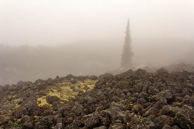
Endless boulders and no visibility

Crossing a small washout
After 2.5 miles of walking through the maze of boulders trying to follow the wooden poles, we reached another junction with Butte Camp trail. Another 2 miles from there was the first big hurdle of the day. We had to go across the big washout in sheep canyon area. We had been crossing washouts all day till then, so when someone said this one is big, there was a part of me who said "F*&K..so what have we been till know!". I didn't take any pictures while scrambling up and down the scree side slopes on the canyon wall, but we managed to get up on the other side.

Once we got to the canyon, it seemed like the original trail was diverted downstream on the canyon wall due to some old washout. It is about a mile long detour. As soon as we climbed out of the canyon, weather started opening up a little bit and we had our first view of the mountain. At this point we were about 10 miles from the TH. We crossed the junction with sheep canyon trail and there was blue sky in front of us.  
First views of the day
From here, the trail was heavily forested. We went over a hill and on the other side to the South Fork Toutle River. Last mile, even though it was all downhill felt like eternity! Finally, I was able to see the river. I was happy that the day was over and I can rest, but at the same time I saw what I need to cross first thing in the morning! I was a little frightened by that.
What's on the menu for the breakfast
We had a nice conversation about the exciting day that we passed through and the challenges on the next day at the dinner table. Everyone was dead tired and it was bedtime at 9PM!

Day2: South Fork Toutle River to Plains of Abraham


Night was calm and I had  sound sleep after a long hard day. We woke up to a beautiful morning with partly cloudy sky. We all knew we have a hard day in front of us and I could feel that nervous energy at breakfast among us.

First thing in the morning - drop down to the Toutle River Canyon, find a crossing and get back up on the other side. We couldn't find a dry crossing, so it was time to put on sandals and wade. This whole up-down and wade part was certainly entertaining. 
Getting Down
Going back up on the otherside
Once back up on the other side, the whole day was supposed to be non-eventful except the last part where we have to go up the windy pass and come down on Plains of Abraham. We were still walking in thick clouds with nothing much to see. 
Walking in the clouds
Once we got into the blast zone, the weather cleared up and we could see the whole mountain and crater right in front of us.

This whole day was so much full of little ups and down, it felt even more tiring than the first day. Also, uncertain about our next water source and not knowing how much I have left in the water bladder, I started drinking less and less in an effort to conserve water. That made me dehydrated and not to mention glow in the dark pee at the end of the day. Closer we got to the Loowit falls, there were couple of stream crossings, which also meant water. It was just full of silt. I had to keep back flushing my filter all the time. After Loowit Falls, there was a fresh water spring. Since I knew I was dehydrated, I filtered a couple liters and drank one. It felt like life sprung back in my body. 

Soon, we got to the windy pass and 3 or 4 switchbacks later at the top. Tricky part was going downhill from there. From what I could remember from my day hike a year ago, it was all loose scree and coming down was little challenging. It lived up to the expectations. After getting down, we took a long break before walking across to Plains of Abraham. We found a nice camp spot on the plains next to the water source. 
Windy Pass in the background
Although, we didn't have any major uphill section on this day, we were slow as a whole group and everyone was super tired. Soon, I gathered 4 liters of water and I must have drank 2 liters out of it during dinner and the rest of the night. 


Day3: Out to the pizza!


I woke up at 5 to see the sunrise, but clouds had rolled in and again we were in the cloud. So after a lazy breakfast, everyone packed up and was stocked to see the end of this trail. We were still in clouds and visibility was very poor.

This was supposed to a very straight forward day with downhill for the most part. We still had to cross 2-3 deep canyons. It was challenging, but nothing like Troutle River. We were lazy walking this whole day. After 5 miles or so, I saw the timberline. I have never been so happy to see the end of any trail. In 1/2 mile or so, I came to a junction with June Lake trail - 2 days ago we started counter-clockwise from here. YAY!!!! 
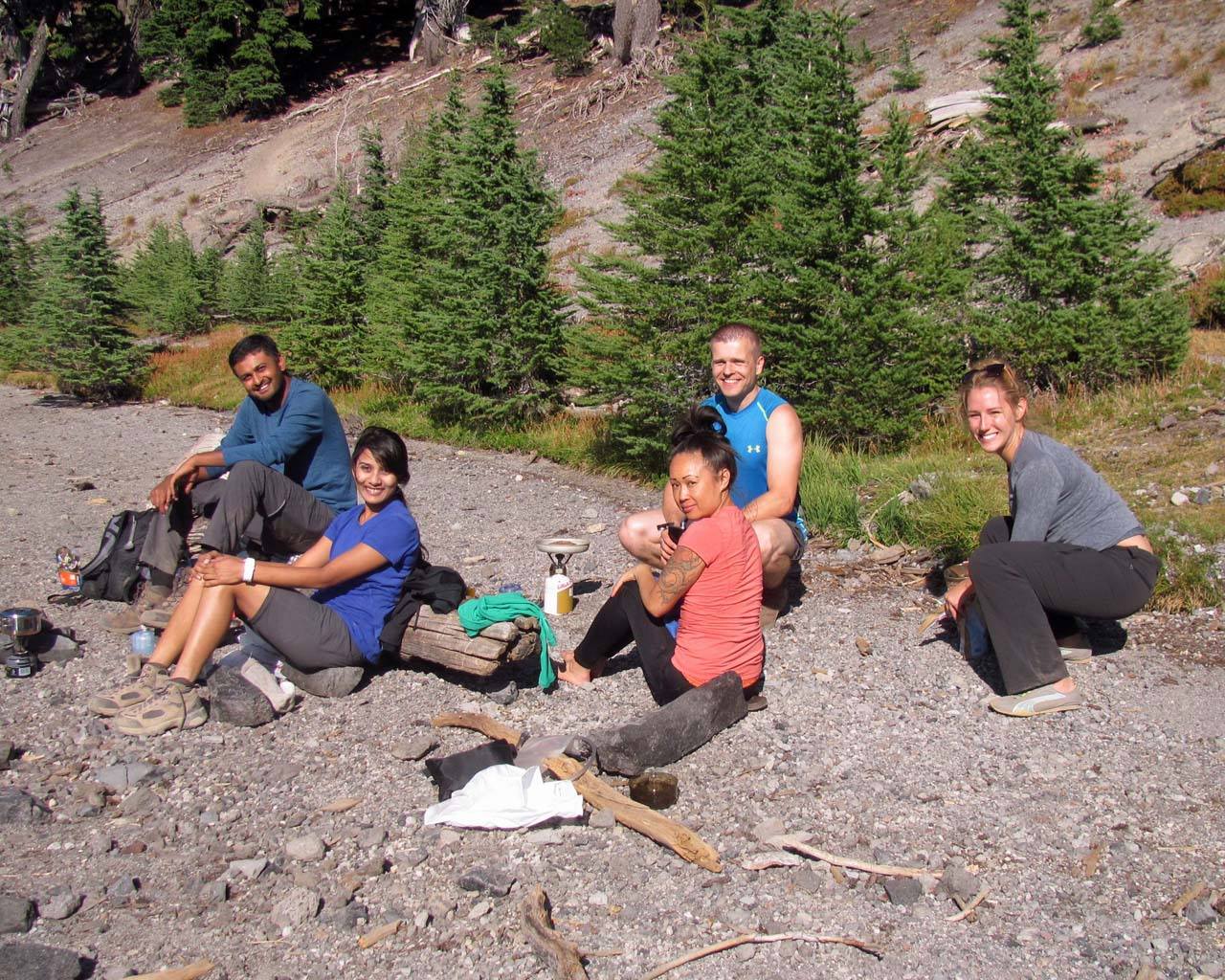
Groups Shot!
All in all, this was a FUN trip. It is not your typical run-of-the-mill backpacking trip. I don't think I can explain the difficulty level of this hike in words (If I had to rate it, this would be 9/10). Would I do this again? May be no, but I certainly had some good sections. Going around an active volcano - I certainly saw drastic changes in the surroundings - going from think green woods to moonlike area in the blast zone. It was a nice group that made this possible!

Open this map full screen.

Cooper Spur Stone-shelter Overnight

I had stayed overnight at the shelter last summer and I had an amazing time. Being right under the summit and listening to the glacier move, it made me feel small, but at the same time it was very peaceful and calming experience. After looking at the trip report from a someone a week before and seeing that snow level have receded, I made plan to go there again. Since this is still very early in the season - baring the extreme low snow year we had, the road to Cloud Cap Inn was still gated. We had to start at the lower TH.

The trail was very dry until we got to the Tilly Jane A-Frame. We hit the snow soon after passing the A-frame. Route finding wasn't an issue, since the trail is flagged for the skiers and there were lots of footprints. We headed straight up towards the shelter. We got to the shelter in the afternoon and spent the rest of the evening taking a nap. Once the sun went a little lower, we went up towards cooper spur, but had to turn around due to precarious snow condition. Snow was very soft and I didn't feel safe without an ice axe. We got back down after sunset. After dinner I stayed up to shoot some stars. Sunrise on the following morning wasn't perfect because for clouds by he horizon, but I still managed to get few shots.

Sunset above the stone shelter
Sunrise