
Elevation Gain (Cumulative): 12096ft
Days spent: 5 days
Planning phase - When I got the permits, I was super stoked that I will be standing on top of Mt Whitney - the tallest peak in contiguous US - this summer. Backpacking wasn't new to me, so planning for food or gear was not much of a big deal. I was mostly researching about cool camp spots with great sunset/ sunrise views. Two months before the hike, I booked my car shuttle between Onion Valley TH and Whitney Portal. Everything was setup for an epic adventure. And then..
All my hiking buddies have already bailed out on me sometimes during the month of June. Here I was..trying to convince myself to go solo and at the same time convincing the family that I can make it. The idea of solo hiking was terrifying to me since I hadn't done anything longer than a solo overnight - let alone 6 days. With me going solo, apart from hiking challenge, there was transportation challenges. I'd have to drive more than 800 miles overnight to get to Lone Pine and start hiking immediately. So, as the days came closer, my excitement started turning into worry and nervousness.
 |
| Gear Stack |
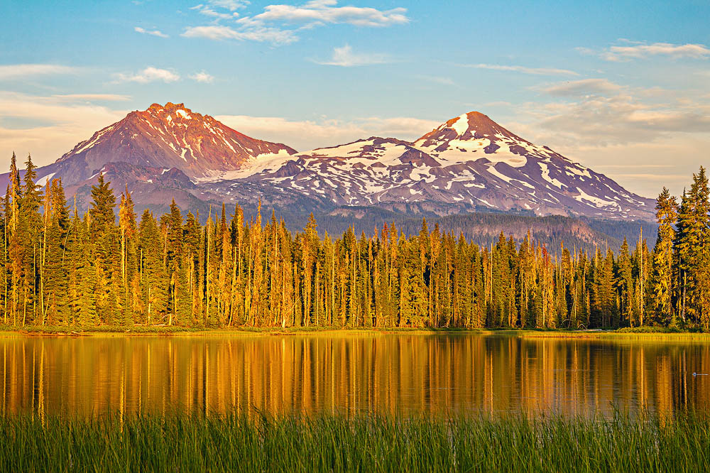
Start: Onion Valley trailhead
End: Kearsarge Lakes
Hiking Stats: 5.75 miles, 2700 feet elevation gain
My first day started with an adventure. After an overnight drive from Portland to Lone Pine, I got there at about 4AM. After parking my car by the roadside, I took a nap for couple of hours, took a shower at a hostel. I then called my shutter service guy and no answer. I called 10 mins later and some lady answered and she didn't know where he is and told me that she will give my message to him. I wasn't too worried up until now. I picked up my permit grabbed breakfast. That took me almost an hour. So, I call the guy again, same lady answered and said he is in the emergency room. I was like "what the F$*K! what am I going to do now?" After a bit of conversation, the lady on the phone gave me a phone number and said he should help you. I called the other guy, no answer. I call him again still no answer. I started to panic at this time. I thought let me drive to Independence and then I will see if I can hitch a ride to Onion Valley TH. As I was driving, I got a call back and he said I can shuttle you, but earliest he can pick me up will be noon. I had no option but to say yes. This meant that I won't be on the trail until 2 PM. After all this, I finally get to the trailhead just before 2PM. I said my final goodbye and headed uphill. It was a nice sunny day with may be couple of fluffy clouds around.


Afternoon thunderstorms were not even on my mind until now. It was a 6 miles day and I had plenty of day light left, so I was taking my time.By the first couple of miles, I realized that this is not going to be an easy trip. I was already tired and every step that I take was a struggle. An hour or so after I started hiking, I see those cople of fluffy clouds are starting to form into a big thunderhead. Thousand feet below the pass I was and clouds looked very ominous and I started hearing thunder or may be that was just my imagination - I don't know. Finally I get to the top of the pass and dropped my pack for few pictures. I must have spent about 30 mins at the top, snapped few photos and started downhill. By this time I was so tired and out of it, I just wanted to lay down and sleep. I quickly found a campsite by Kearsarge Lakes, shot few sunset pictures and cooked my dinner. I hadn't eaten anything other than couple of pancakes since morning, but I still couldn't finish my dinner (May be altitude effect!)

After settling down in my tent, I looked at my map to plan for the day 2. For some reason when I planned the trip, I though day 2 was "easy pizzy", but after 10 mins of staring at the map, I realized it was not the case.
Day 2:
Start: Kearsarge Lakes
End: Below Forester Pass (11,300 feet)
Hiking Stat: 8.5 miles, 2200 feet elevation gain

I think about this even now when I writing this post. I remember it clearly that on the first night, I was so tired and exhausted and number of things hasn't gone very well. I told myself if I don't start feeling better today then it is time to turn back. I gathered all the mental strength that I could find and started walking along the trail. Very soon I met with JMT and my very first through hiker. Just 5 mins chat with him lifted me up greatly. I made my down to Vedette Meadows and kept following Bubbs Creek Valley. The view was just amazing. Kept stopping for pictures every so often. In fact it was just an excuse for stoping and catching my breath.
Once I was all the way down in the valley, it was time to go around the Center Peak and plan was to camp a mile before the forester pass. Even if the trail climbs very moderately - 2000 feet in 4.5 miles, I was dead tired. I looked at the datebook and found that below 12000 feet lake, there is a campsite with spectacular views and water. When I got there, the view didn't disappoint. I made that spot my home for the night.
 |
| Pano from the campsite |
Day3:
Start: 11,300 feet (3 miles before Forester Pass)
End: Bighorn Plateau
Hiking Stats: 10.5 miles, 2700 feet elevation gain
I knew I had a long day, so I packed up before the sunrise and snapped a few shots and I was on way upwards towards the pass. I didn't think I was going to be fast and so was the case. I covered 3 miles in 3 hours and was passed by bunch of through hikers.

I knew I had a long day, so I packed up before the sunrise and snapped a few shots and I was on way upwards towards the pass. I didn't think I was going to be fast and so was the case. I covered 3 miles in 3 hours and was passed by bunch of through hikers.
 |
| Lake at 12,250 feet |

 |
| Looking south from the Forester Pass |
 |
| Looking North from the Forester Pass |
Standing at the top of the pass, I could see my destination for the day. It really looked miles away (7 miles in fact). After soaking in the views and few nuts, I started going downhill. Passed few lakes and streams before entering the forest again. As much as I liked the open country, trees were a nice welcome. Few switchbacks after passing Tyndall creek ranger station junction, I reached the Bighorn Plateau. I setup my camp and walked around a bit. Since the campsite was fairly exposed and not a very popular one among the through hikers, I thought I will have the place to myself. But just before the sunset couple of north bound guys camped there to give me some company. Night time temps here dropped down below freezing and I woke up to a frozen Nalgene canteen outside my tent.
 |
| Bighorn Plateau and Tawny Point in the background |
Day4:
Start: Bighorn Plateau
End: Guitar Lake
Hiking Stats: 10 miles, 2100 feet elevation gain
Knowing that there is chance of thunderstorms and rain in the afternoon, I started my day right at sunrise. I made my way down to Wallace Creek crossing in no time. From here it was mostly uphill to Guitar Lake. On the way I pass many SOBO JMT-thru hikers. They just blazed past me and disappeared within few minutes after crossing me.
I got to Guitar Lake around 1 PM, rested for a bit. I could already see some thunder clouds brewing in the distance. Before pitching my tent, I contemplated hard to go summit Mt Whitney knowing the next days forecast. According to the forecast, they were predicting some severe weather and snow on higher elevation. Storm really came in as said in the forecast and it rained so much that at one point I was worried that if my tent would hold up or not.
I got up at 2 in the morning and when I looked up, I saw stars in the sky. That means it was time to start packing and hike out in the dark. I was averaging about 800 feet an hour and got to Mt Whitney trail Jct half an hour before sunrise. By this time it had turned from clear stary night to really vibrant colors all around me. Few hundred feet after I left Guitar Lake, I was walking on some slushy snow on the ground. It was cold and windy and soon it started blowing snow sideways furiously. Visibility was reduced to nearly 100 feet or so. I unloaded my tent, bear can and all extra items at the trail junction and started walking towards the summit. The condition kept getting worse. I stopped for 5 mins, thought about it - is the summit that important? #summitsareoverrated. I decided to turn around, gathered my stuff and started walking downhill towards trail camp. I think after I past trail crest, the weather had cleared up again, but I was way to tired to make another attempt.

Final GPS Track

Start: Bighorn Plateau
End: Guitar Lake
Hiking Stats: 10 miles, 2100 feet elevation gain
Knowing that there is chance of thunderstorms and rain in the afternoon, I started my day right at sunrise. I made my way down to Wallace Creek crossing in no time. From here it was mostly uphill to Guitar Lake. On the way I pass many SOBO JMT-thru hikers. They just blazed past me and disappeared within few minutes after crossing me.
I got to Guitar Lake around 1 PM, rested for a bit. I could already see some thunder clouds brewing in the distance. Before pitching my tent, I contemplated hard to go summit Mt Whitney knowing the next days forecast. According to the forecast, they were predicting some severe weather and snow on higher elevation. Storm really came in as said in the forecast and it rained so much that at one point I was worried that if my tent would hold up or not.
 |
| Camping under Mt Whitney |
 |
| Incoming!! |
It stopped raining momentarily before sunset. I stepped outside my tent and turned my eyes towards Mt Whitney..First thoughts..F$*k I THINK I SEE SNOW!! Cooked my dinner and decided I will wake up at 2 if it had cleared out and start climbing at 3 AM to summit at sunrise.
Day5:
Start: Guitar Lake
End: Whitney Portal
Hiking Stat: 12.5 miles. 2800 feet elevation gain
I got up at 2 in the morning and when I looked up, I saw stars in the sky. That means it was time to start packing and hike out in the dark. I was averaging about 800 feet an hour and got to Mt Whitney trail Jct half an hour before sunrise. By this time it had turned from clear stary night to really vibrant colors all around me. Few hundred feet after I left Guitar Lake, I was walking on some slushy snow on the ground. It was cold and windy and soon it started blowing snow sideways furiously. Visibility was reduced to nearly 100 feet or so. I unloaded my tent, bear can and all extra items at the trail junction and started walking towards the summit. The condition kept getting worse. I stopped for 5 mins, thought about it - is the summit that important? #summitsareoverrated. I decided to turn around, gathered my stuff and started walking downhill towards trail camp. I think after I past trail crest, the weather had cleared up again, but I was way to tired to make another attempt.
 |
| Before the storm arrived |
Final GPS Track


